Salt Lake City's growth has always been a negotiation with topography. The original 1847 grid, laid out by Mormon pioneers, stretched flat and orderly across the valley floor. But as the metro area pushed east toward the Wasatch Range and north into the benches, development collided with steeper terrain, ancient Lake Bonneville sediments, and a groundwater regime that still surprises engineers. Today, a slope stability analysis in this city means confronting layered deposits of sand, silt, and clay left by a Pleistocene lake that once covered the entire valley. Add in seismic demands from the nearby Wasatch Fault Zone — one of the most closely watched normal fault systems in the Intermountain West — and you understand why geotechnical work here starts with careful stratigraphy. The team approaches every slope assessment by mapping the interface between natural colluvium and the underlying Lake Bonneville formation, because that contact zone is where pore pressure builds and failure surfaces often initiate. For deeper investigations, we integrate data from CPT soundings to capture continuous soil behavior profiles without the disturbance that conventional sampling can introduce in sensitive silts.
Bench lots in Salt Lake City often sit on the contact between Lake Bonneville sediments and Wasatch colluvium — that's where pore pressure builds and slopes move.
Service characteristics in Salt Lake City
Demonstration video
Risks and considerations in Salt Lake City
At roughly 4,300 feet above sea level, Salt Lake City occupies a basin where the risk of slope failure is driven by two factors that don't always appear together: a semi-arid climate that masks seasonal groundwater spikes, and a fault system capable of producing a magnitude 7.0 event. The Wasatch Fault has a recurrence interval of about 1,300 years on its central segments, and the last major rupture occurred roughly 1,400 years ago — meaning we're in the window. A pseudostatic slope stability analysis that ignores this reality is simply incomplete. Beyond seismic loading, the city's record-setting winters — Alta, just up Little Cottonwood Canyon, averages over 500 inches of snow annually — generate rapid spring melt that infiltrates slope materials and can trigger shallow translational slides in colluvial deposits. The 1983 Thistle landslide, while farther south, remains a benchmark case for what prolonged groundwater pressure can do to weak sedimentary formations in this region. State Route 92 through American Fork Canyon sees recurring rockfall and debris flow activity that keeps geohazard assessment on the agenda for every transportation project.
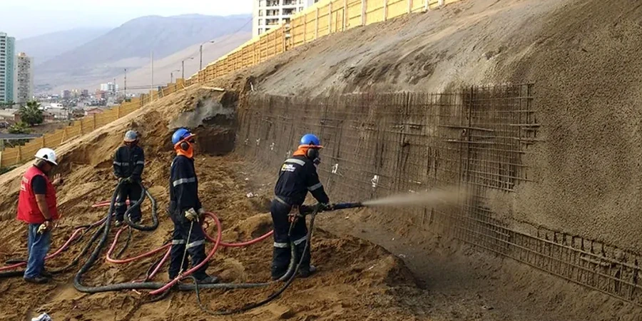
Our services
Slope stability assessment in Salt Lake City requires pulling together several investigation methods that each answer a specific question. Our accredited laboratory operates under ISO/IEC 17025 and supports these services with in-house triaxial, direct shear, and index testing so that strength parameters used in the analysis come from the same formation being modeled. Below are two complementary services that often run in parallel with a stability study.
Instrumentation and Monitoring
We install inclinometers, piezometers, and survey prisms on active or suspect slopes, then read them on a schedule tied to seasonal groundwater changes. The data feeds back into the stability model to validate assumptions and, when movement is detected, to trigger the threshold alerts defined in the project's geotechnical instrumentation plan.
Mitigation Design Support
Once the failure mechanism is understood, our engineers work alongside the structural and civil team to size retaining structures, ground anchors, soil nail walls, or drainage systems. We provide the earth pressure diagrams, bond length calculations, and global stability checks that let the designer specify a system with confidence.
Common questions
What does a slope stability analysis cost for a typical Salt Lake City residential lot?
For a single-family residential slope evaluation on a standard bench lot, the analysis typically ranges from US$1,190 to US$4,770 depending on the number of cross-sections, whether seismic loading is required, and how much lab testing is needed to define the strength envelope. Complex sites with multiple failure modes or the need for finite-element modeling fall at the upper end.
How does the Wasatch Fault affect the pseudostatic analysis?
The Wasatch Fault's proximity means site-specific peak ground acceleration values are relatively high for an intraplate setting. We apply a horizontal seismic coefficient derived from the mapped spectral acceleration at the site, reduced for allowable permanent displacement if the slope is not critical. The IBC references ASCE 7 for these parameters, and we typically run both a pseudostatic analysis and a Newmark-type displacement check when the factor of safety drops below 1.0 under seismic load.
What soil parameters do you need to start a stability model?
At minimum, we need the effective cohesion and friction angle for each distinct layer, along with the saturated and moist unit weights. If groundwater is present, we also need a phreatic surface or pore pressure profile — that's often the single biggest control on the result. These parameters come from triaxial or direct shear tests run on high-quality samples, and we much prefer to test material from the same boring log rather than rely on textbook correlations that may not reflect local Lake Bonneville deposition.
How long does the analysis take from field investigation to final report?
A typical timeline runs four to six weeks after drilling is complete. The lab needs about two weeks for consolidated-undrained triaxial tests with pore pressure measurement, and the modeling phase takes another week to ten days once all input parameters are finalized. If inclinometer data is being used to calibrate the model, we add a baseline reading and at least one follow-up, which pushes the schedule out by a month or more depending on seasonal conditions.